From Trash to Treasure, the Former Fulbright Landfill/Superfund Takes on New Life
Category Spotlight On | Posted on July 13, 2020
Your newest section of trail is the "return to use" of the former Fulbright Landfill & Superfund Site
Head outside to explore your newest section of trail! In this time of the COVID19 pandemic, people have sent a message loud and clear. Whether looking for respite, fun, or an opportunity to get out and socialize (from a distance,) where have they gone? Outside. Trails and parks have experienced a tremendous uptick in people using and enjoying these places. This unprecedented demand for places to bike, walk and wheel highlights the value that trails have always delivered to communities –connected trail systems protect and conserve our outdoors, support healthy activity, provide transportation choices for all, and serve as catalysts for transformative community development and redevelopment.
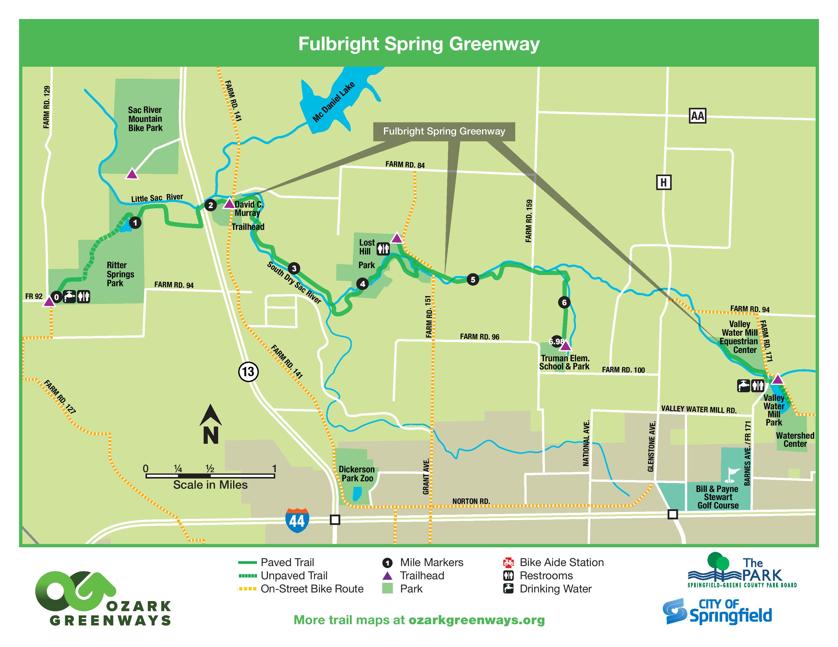
Project Details & Connectivity. This $484,189 project consists of construction of 8,103.20 l/f of a new, hard surface trail for bicycling, running, and walking activities. We will also enhance the 6.98-mile corridor with public art, interpretive kiosks, and wayfinding. This project will fill a trail gap within the Fulbright Spring Greenway trail corridor. It will directly connect 2 parks (see below map between MM 3 & MM 4) and will result in a total of 6.98 continuous miles of trail connecting a total of four parks, one elementary school, several subdivisions, a 1-mile natural surface loop trail used by hikers/runners/mtn. bikers, and an additional rural road bicycle route which is signed with share-the-road signs to connect to the Frisco Highline Trail. Future connectivity will include continuation of this trail east to the Watershed Committee of the Ozarks Education Center, trail connections to the future Little Sac Greenway trail to McDaniel & Fellows Lake recreation areas, existing Sac River Mtn. Bike Trails, and future Dirt 66 Mtn. Bike Trails. The future Pea Ridge Creek Greenway trail will connect the City of Springfield to the Fulbright Spring Greenway trail at David C. Murray Trailhead. Learn more about this trail by clicking here.
Parking & Trail Access:
Ritter Springs Park 3683 W. FR 92
David C. Murray Trailhead 4769 N. FR 141 (nearest trailhead for new section)
Lost Hill Park 4705 N. FR 151
Truman Elementary School 3850 N. FR 159
The immediate area was once the former Fulbright Landfill/Superfund Site. Today we see a mix of native prairie grasses and wildflowers, as well as a variety of wetland and woodland trees and shrubs such as oak, American Sycamore, sassafras and willows. This former landfill site serves as habitat for a range of wildlife including turtles, deer, foxes, woodchucks, and many bird species such as songbirds, wild turkeys, hawks, and bald eagles. The property is owned by the City of Springfield and is a great example of many partners working together to co-create a community asset. The beautiful South Dry Sac River meanders alongside Fulbright Spring Greenway and feeds into the Little Sac River just east of Hwy 13. Also nearby is Fulbright Spring which is located on property owned by City Utiltiies. Fulbright Spring is the city’s original water source, and Springfield began using the spring in 1883. This site is still in use and became a National Historic Landmark in 1993.
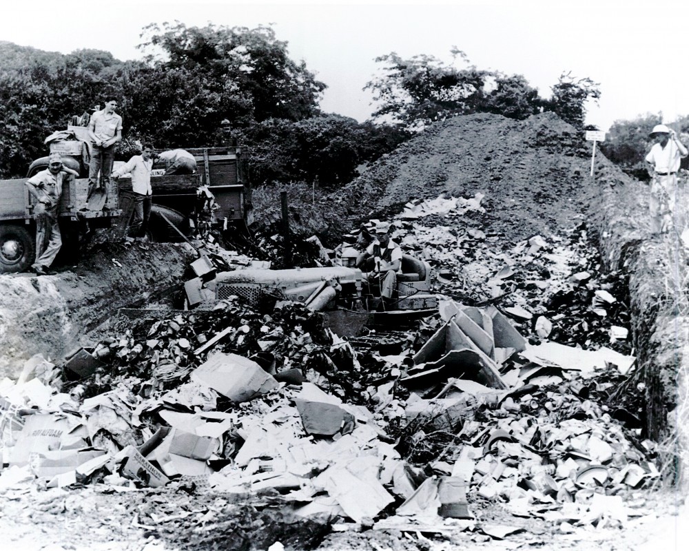
But it wasn’t always so pretty here. It wasn’t until the 1970s that American cities began to understand the need for critical storage and handling processes to prevent their waste from damaging human and environmental health. Springfield discovered its own need for these processes, after it was determined in that the Fulbright landfill was contaminated. The City of Springfield operated the former landfill from 1962-1969 (see above picture from this site in the mid 1960s.) During this time, domestic and industrial wastes were accepted. At that time it was standard practice to place trash and waste into long trenches next to the river. After the trenches were filled, they were covered with soil. Additionally, other areas were designated for disposal of spent solvents, plating waste, and other liquid chemical wastes. Needless to say, this improper disposal created a very bad problem.
In order to correct the problem, the 98-acre Fulbright Landfill was designated a Superfund site and added to EPA’s National Priority Listing (NPL) in 1983 as a hazardous waste site. In 1990, the City entered into a consent decree with EPA to perform cleanup activities to address volatile compounds, heavy metals, and cyanide contamination found at the Fulbright site.
What is a Superfund? The EPA began its “Superfund” emergency toxic waste cleanup program when it became federal law in 1980. Congress’ action was in response to national public outrage over learning about the horrible impact on health after the results of the 1970’s toxic waste spills in the “Love Canal” in Niagara Falls, and the “Valley of the Drums” disaster in Kentucky. Both harmed hundreds of residents and required high-level emergency cleanup operations. In response, Congress established the Comprehensive Environmental Response, Compensation and Liability Act (CERCLA) in 1980. CERCLA is informally called Superfund. It allows EPA to clean up contaminated sites. It also forces the parties responsible for the contamination to either perform cleanups or reimburse the government for EPA-led cleanup work. This period in our nation’s history spread awareness of how important it is to prevent toxic disasters. For more about Superfund projects, visit www.epa.gov/superfund. To learn more about the health and environmental performance measures for this site, please click here.
Successful Remedies. Decades after the landfill closed, the streambank of the river eroded, exposing trash and debris. Decontaminating the site included excavating and removing trash and contaminated soil from the streambank, backfilling with clean material as well as laying down mesh mats and concrete blankets. Trees were planted along the river to help reduce future erosion and stabilize the streambank. The City continues to monitor the site annually to ensure it meets accepted environmental standards. We also have trail signs posted on each end of the trail segment that crosses the former landfill/superfund site requesting that trail users stay on the trail.
See below for a high-level timeline of events related to this site.
1962 – 1969: City operated the Fulbright landfill and it was closed in 1969 due to reaching landfill capacity
1978 – 1981: MSU geology student discovers high concentrations copper, chromium, lead, and manganese in surface soils near the streambank along the Fulbright landfill; EPA places site is listed as a Federal Superfund site.
1990 - 1992: Site Remedial Action Plan developed by the City and EPA to address corrective actions; removal of contaminated wastes and soils completed
2004 – 2006: Major erosion and ponding issues addressed by the City; Site selected by the EPA as one of its 11 demonstration projects across the country for its “Return to Use” initiative. Trees planted to create a woodland buffer and help maintain surface stabilization; additional site soil capping activities completed
2013: Sediment sampling completed along the stream
2015 - 2016: Environmental Covenants and Restrictions agreed to by EPA and the City to allow for recreational use of the Fulbright site; additional soil sampling along the proposed Ozarks Greenways trail alignment required
2017 – 2019: Additional soil sampling completed by Environmental Works & Reuse is a reality as the project receives clearance from the NEPA Review process and EPA
2019: Ozark Greenways contracted with Towe Construction on 500 L/F of trail on the east end of the trail just west of Lost Hill Park
2020: Ozark Greenways contracted with Emery Sapp & Sons on the remaining 1.44-mile trail project (between MM3 & MM4 on below map) which will fill a key gap in this planned trail alignment
July 13, 2020: Soft opening of the trail segment. The following activities are still underway: fundraising, SWPPP close-out, interpretive kiosk, benches, mural, and way-finding sign installation
September 2020: Trail Completed! Fundraising, SWPPP close-out, benches, mural, sculpture, way-finding, and interpretive kiosks completed/installed.
2020 & Beyond: Partners will be filling a trail gap between Truman School-Park and Valley Water Mill Park & Watershed Committee of the Ozarks Educational Facility
Partners: City of Springfield Environmental Services, EPA Region 7, Missouri Department of Natural Resources, Springfield-Greene County Park Board, Greene County, & Ozark Greenways. Now that the trail is built, it becomes a linear park within the Springfield-Greene County Park System and they execute the on-going maintenence and management of the trail.
Funding Status: FULLY FUNDED!
Funding History: In 2016 we began fundraising for this trail segment as a part of our Trails for Generations Funding Initiative. The Trails for Generations Funding Initiative addressed four trail segments, and this was one of those 4 segments. In 2017 we were awarded a $150,000 Recreational Trails Program grant and had enough funds raised based on the 2016 engineer’s estimate. We began the required National Environmental Protection Agency (NEPA) Review, which took twenty-two months due do the complex nature of the former superfund site and the surrounding area. Due to increases in construction costs, we did not have enough funds raised to cover the cost of construction. The Board of Directors made the determination and passed a Board Resolution in December of 2019 to apply to the Community Foundation of the Ozark’s Mission Related Investment fund so that we would not have to start the bid process over and/or return the $150,000 grant. We also anticipated construction costs continuing to increase. We received $135,000 under a three-year term on January 3, 2020, from Community Foundation of the Ozarks through their Mission Related Investment program. Ozark Greenways’ goal is to meet the Community Foundation of the Ozarks’ repayment terms by the end of year one. We strongly desire to have this project fully completed and funded by December 30, 2020. In February we conducted a Cause Momentum On-Line Campaign via Community Foundation of the Ozarks and raised $17,260 from 41 donors. In May we applied for received $10,000 from the Missouri Humanities Council for this project to complete the planned interpretive kiosks. Unfortunately, COVID-19 has negatively impacted our fundraising efforts as several potential funders redirected funds towards COVID-19 relief program efforts or reduced charitable giving for 2020, and we cancelled our two main fundraising events for 2020 due to event size restrictions and public health best practices. The final funding piece came into place with a generous gift from The Sunderland Foundation. Their $108,000 donation allowed us to repay our Mission Related Investment with Community Foundation of the Ozarks in August of 2020.