Ozark Greenways

Dirt 66: Fellows Lake Trails

The Fellows Lake Trails are an exciting addition to our region's trail system! This 800-acre City Utilities property currently offers over 25 miles of interconnecting natural surface trail through the woods with views of the lake. The trails are open from sunrise to sunset. These natural surface (aka soft surface/unpaved)  trails are open to hiking, running, and are optimized for mtn. biking.   Please remember that the Nature Hiking Trail is only open to hikers/runners. 

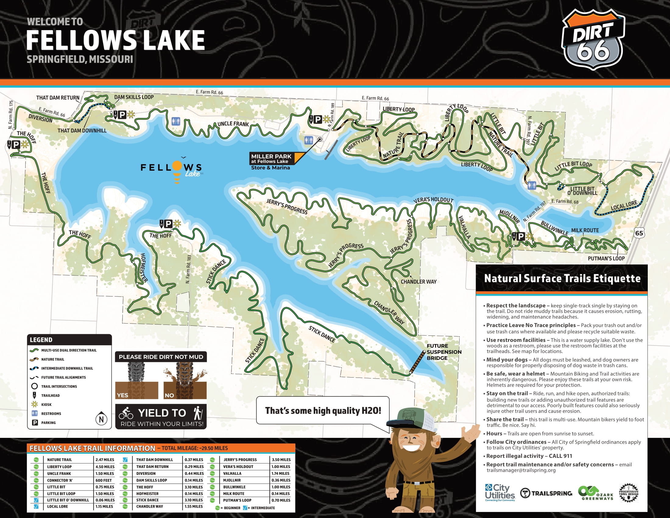
Dirt 66:  Fellows Lake Trails. Click HERE to see a map. 

  • Uncle Frank's Trail:  1.70 Miles 
  • Liberty Loop:  4.5 Miles 
  • That Dam Downhill & That Dam Return:  .8 Mile
  • Little Bit:  .75 Mile 
  • Little Bit Loop:  1.5 Miles 
  • Little Bit O'Downhill:  .06 Mile
  • Local Lore:  1.5 Miles 
  • Bullwinkle:  1 Mile 
  • Milk Route:  .14 Mile 
  • Putman's Loop:  .70 Mile 
  • Valhalla:  1.74 Miles 
  • Mjollnir:  .36 Mile
  • Chandler Way 1.55 Miles 
  • Jerry's Progress 3.50 Miles 
  • Vera's Holdout 1 Mile
  • Phase 8:  Suspension Bridge - City Utilities received grant funding - Under Design
  • Stick Dance:  4.1 Miles
  • The Hoff:  3.10 Miles 
  • Hofmeister:  .14 Mile 
  • Diversion:  .5 Mile 

HOW TO SUBMIT A TRAIL MAINTENANCE REQUEST: Please email jeff@ozarkgreenways.org or 417-501-4674.  Please know the trail segment name, and the nearest mile marker/landmark, and state the request (downed tree, etc.)

RESERVING FELLOWS LAKE TRAILS & RECREATION AREA FOR EVENTS: To hold an event requires a fee and a license agreement with CU, please complete this form: https://www.cityutilities.net/community/lake-events/. You may direct any reservation questions to Kelli Quinn at 417-831-8881 or kelli.quinn@cityutilities.net

TRAIL ETIQUETTE & SAFETY TIPS

  • Know where you are - know where you parked and the name of the trail segment you are on. If you have a cell phone, take a photo of the map and trailhead.  Additionally, you may pull up maps to see where you are, drop a pin to send to a friend if you get turned around, or text it to 911 if you hurt yourself. 
  • Share your location - let a friend or family member know where you are going and when you plan to return.
  • Respect the landscape - keep single-track single by staying on the trail. Do not ride or hike muddy trails because it causes erosion, rutting, widening, and trail care concerns. 
  • Practice Leave No Trace principles - pack your trash out and/or use a trash can where available, this includes your dog's poop. 
  • Use restroom facilities - this is a water supply lake. Don't use the woods as a restroom. 
  • Mind your dogs - all dogs must be leashed, and dog owners are responsible for properly disposing of dog waste in trash cans. 
  • Be safe, wear a helmet if you are on a bicycle.
  • Stay on the trail - ride, run, and hike open authorized trails. Building new trails or adding unauthorized features are detrimental to our access. Poorly built trails and features could also seriously injure other trail users and cause erosion.
  • Share the trail - these trails are multi-use, except the Nature Hiking Trail is hiking only. People on bicycles yield to foot traffic. Be nice. Say hi.
  • Hours -Trails are open from sunrise to sunset.
  • Follow City Ordinances - all City of Springfield ordinances apply to trails on City Utilities' property.
  • Report illegal activity - CALL 911
  • Report trail maintenance and/or safety concerns - email jeff@ozarkgreenways.org

INHERENT RISK WARNING: Inherent risks as those so integral to an activity that, without them, the activity loses its basic character and appeal. These are risks of injury or loss that cannot be reduced or avoided without changing the basic nature of the activity. Mountain biking, hiking, trail running, trail maintenance, and other outdoor activities have inherent risks that may result in bicycle damage, personal injury, or death.  These activities carry with them significant risks. Please enjoy these trails at your own risk. Use of these trails is voluntary. 

POINTS OF INTEREST: Fellows LakeFellows Lake Nature Trail (hiking only); Small Picnic Pavilions; Large Pavilions; Public Restrooms (porta-potty); Dock; Marina Store with ice cream, water, and sports drinks for sale.

NEARBY MTN. BIKE TRAILS:  The Ozarks have some of the world's best and most scenic mountain biking trails! Inquire at any of Springfield's bike shops for more information about area mountain biking. Some local MO favorites also include Sac River Mtn. Bike TrailsTrailSpring's Two Rivers Mountain Bike ParkBusiek State ForestStockton Trails, Lone Pine Bike Park, and White River Valley Trail System. Some AR favorites include The Oz Trails.

CLUBSMissouri Off-Road Cyclists (MORC) and Springfield Youth Cycling Club. Springfield's bike shops are also a great source of area mountain biking information and gear.

HISTORY:  A network of trails around Fellows Lake was first identified in the Springfield-Greene County Vision 2020 Comprehensive Plan.  The current network of trails that surrounds Fellows Lake is one portion of the Dirt 66 Trail Plan that will span from Fellows Lake on the east to Sac River Mtn. Bike Trails on the west.  Plans may include integration with the Fulbright Spring Greenway trail, McDaniel Lake, and several Springfield-Greene County Parks. The Fellows Lake Trails were completed in partnership with TrailSpring,  City Utilities (CU), and Ozark Greenways.  TrailSpring provided the funding and project management of the new trail construction. Ozark Greenways assisted with the project management and serves as CU's Trail Coordinators which includes holding and monitoring the trail license agreement.  Ozark Greenways also manages and coordinates trail maintenance with staff and volunteers, and we fund this work through our annual operating budget (60%) and designated grants (40%.) CU owns the trails, as they are built on CU property that serves as a buffer to one of our community's primary drinking water sources - Fellows Lake. 

Parking & Trail Access

Fellows Lake Recreation Area is generally located at 4200 E Farm Road 66, Springfield MO 65803. 

Trailhead Parking is currently available in these locations:

  • Gate 1 Farm Road 66 - The Dam:  3500 E. FR 66 Springfield, MO
  • Gate 3 Farm Road 66 - Miller Park: 4200 E. FR 66 Springfield, MO
  • Gate 4 Farm Road 197 - Accessible Dock & Restrooms:  6564 N. FR 197 Stafford, MO
  • Gate 5 Farm Road 197 - Valhalla:  6265 N. FR 197 Strafford, MO
  • Gate 7 Farm Road 183- Pavilion:  5902 N. FR 183 Springfield, MO
  • Gate 8 Farm Road 175 - Below the Dam:  6650 N. FR 175 Springfield, MO

Map

Download a printable version of this Ozark Greenways map


Length

25+ Miles 

Terrain

Soft Surface Trails:  natural or unpaved; uneven terrain; uneven natural surfaces

Accessibility

Mountain Biking, Class 1 E-Bikes up to 750 watts, Hiking, Running

Hours

Open Surnrise to Sunset

Interactive Map

  • Gravel
  • Pavement
  • Mulch/Natural
  • Water
  • Bike Lanes
  • Shared Lane Markings
  • Signed Bike Route

Greenway Etiquette

Bicyclists
  • Show courtesy, greenways are for all users.
  • Yield right-of-way to pedestrians.
  • Keep to the right (except to pass).
  • Always pass on the left and give ample room.
  • Before you pass a pedestrian or another bicyclist, slow down and either ring a bell or politely call out “passing on your left”.
  • Stay single file in congested conditions.
  • Ride at a safe speed and enjoy the view.
All Users
  • Share the greenway; be considerate of all users.
  • Stay right, pass on the left. Announce when passing. 
  • If you stop, step off the greenway.
  • Turn down volume on earphones so that you can hear other greenway users.
  • Keep dogs on a leash and clean up after your pet.
  • Report trail hazards in Greene County to Springfield-Greene County Parks at 864-1049.
  • Call 911 to report crime.

We rely on the enthusiasm and financial support of the community.

Learn more about how you can help
© 2024 Ozark Greenways Built by Demi Creative